Emsphere construction start from satellite images
Sentinel-2 satellite images of the Emsphere site stay close to their 2017 state until Q3 2019. Construction started between Q3 2019 and Q4 2019.
Share of the site that changed since 2017
- Construction started between Q3 2019 and Q4 2019.
- The site looked unchanged until Q3 2019.
- At 10 m per pixel a finished building cannot be told apart from one still being fitted out, so this page shows no completion or opening date.
Before and now
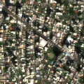
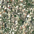 20172025
Drag the divider or use the arrow keys.
The outline is the site footprint. The images are Sentinel-2 true colour at 10 m per pixel.
Method and limits
- Each quarter, every clear Sentinel-2 image is compared with a baseline built from the first four clear quarters of 2017.
- A pixel counts as changed when its vegetation, brightness or bare-soil signal moves by more than the normal variation of the surrounding area.
- The start is the first quarter in which the change is sustained. It is a bracket between two images, not a day.
- Clouds, haze and shadows are masked, but a few false jumps remain.
Contains modified Copernicus Sentinel data, processed by MapScale.